Hanna threatens to drench Philadelphia region
New Jersey's beaches, which have benefited from a decade of relative weather tranquillity, may be in for a rough weekend.
New Jersey's beaches, which have benefited from a decade of relative weather tranquillity, may be in for a rough weekend.
Although the ultimate path and intensity of Tropical Storm Hanna are uncertain, meteorologists warned that whatever is left of it could affect the region tomorrow night and Saturday, perhaps lashing the Shore with 60 m.p.h. gusts and pounding rain.
As much as five inches of rain is possible in some areas, said Jim Poirier, a meteorologist at the National Weather Service office in Mount Holly.
"I would say people should keep an eye on it," said Steven Hafner, a geologist at Richard Stockton College of New Jersey's Coastal Research Center near Atlantic City.
But on a perfectly summery day at the Shore, where the surf showed only the slightest agitation, the prevailing attitude amounted to, "What, me worry?"
Ocean City officials were busily making preparations yesterday not for the storm, but for the weekend's hot-rod show and street fair.
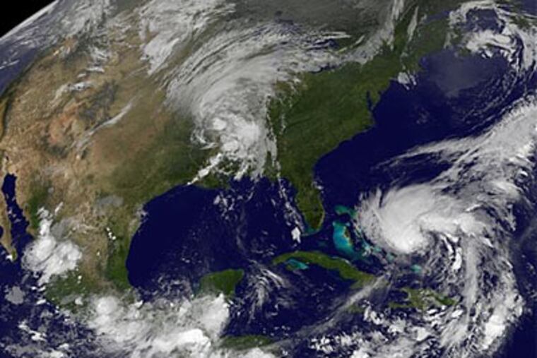
Meanwhile, more than 900 miles to the south, Hanna was taking aim at the Bahamas even as wind shear was inhibiting its development, said Jamie Rhome, a forecast specialist at the National Hurricane Center in Miami.
While Hanna is expected to enter a more nurturing environment over the open Atlantic, it is unlikely to become a mega-storm, he said. It is forecast to be at least a minimal hurricane, however, with winds of 80 m.p.h. before it reaches the Carolina borders Saturday morning.
What happens after that will make all the difference to the Philadelphia region.
Over land, it would lose punch - and probably its name - as sustained winds fell below 39 m.p.h., the minimum for a tropical storm. By the time it gets up this way, it might well be a "nor'easter hidden in tropical clothing," said Anthony Gigi, a National Weather Service meteorologist in Mount Holly.
In fact, yesterday's projected path suggested that Hanna's remnants would take a classic nor'easter track, with the center passing just east of the Shore. That track could well shift in either direction in subsequent computer runs.
Areas west of the center could get soaked with steady rain, said Tom Kines, a meteorologist with Accu-Weather Inc., the commercial service in State College, Pa. Areas to the east, he said, would be subject to stronger winds and more episodic rains in severe storms.
"It would not be surprising to see wind gusts of 60 m.p.h. or better along the coast if the storm tracks west of Atlantic City," Kines said.
Yesterday, however, Hanna was an abstraction on New Jersey's barrier islands, where the Federal Emergency Management Agency has not declared a disaster since February 1998. In that winter, the beaches were battered by a sequence of nor'easters, so named for their northeast winds.
For the most part, said Stockton's Hafner, the beaches are in decent shape. The exception is Strathmere's beach in Upper Township, which has suffered erosion related to the proximity of Corson's Inlet.
The weather service said rip currents could become a problem this weekend because of Hanna, but such warnings are a post-Labor Day staple as the tropical-storm season kicks into gear.
"We have a wait-and-see attitude right now," said Laurie Howey, communications manager for Ocean City. "We have a great emergency management plan in place should anything happen. But we're not anticipating any problems, and instead we're busy getting ready for all the activities we've got happening here this weekend. We'll just all keep our fingers crossed and move ahead with our plans until we get word otherwise."
At the Farley State Marina in Atlantic City, boat dealers and event organizers were putting the finishing touches on the Atlantic City In-Water Power Boat Show, moving multimillion-dollar vessels into the slips.
"Everything is set to go off as scheduled," said Janice Cave, a spokeswoman for the show. "We're not anticipating any problems."
Hurricanes and their remnants, however, are notoriously erratic. The dotted path that appears on the center's hurricane maps is deceptively precise, Rhome said. He invoked the oft-repeated warning that the cone of uncertainty deserves more attention.
"If you're in the cone," Rhome said, "you need to prepare for that system to impact you."
Yesterday, the entire region was in the cone.
Hanna may have a beneficial impact on the region's rainfall deficit. In the last month, rainfall has been 23 percent of normal in Cape May County and 29 percent in Bucks County.
Rain has been so scarce and foliage so thirsty that widespread major flooding is unlikely.
"It's been very dry," Poirier said. "We could use a good tropical soaker."