The Philly region has been a national hot spot this year — for flood warnings
"Ring of fire" thunderstorms and a warm ocean may help explain the summer of floods in the Philly region.
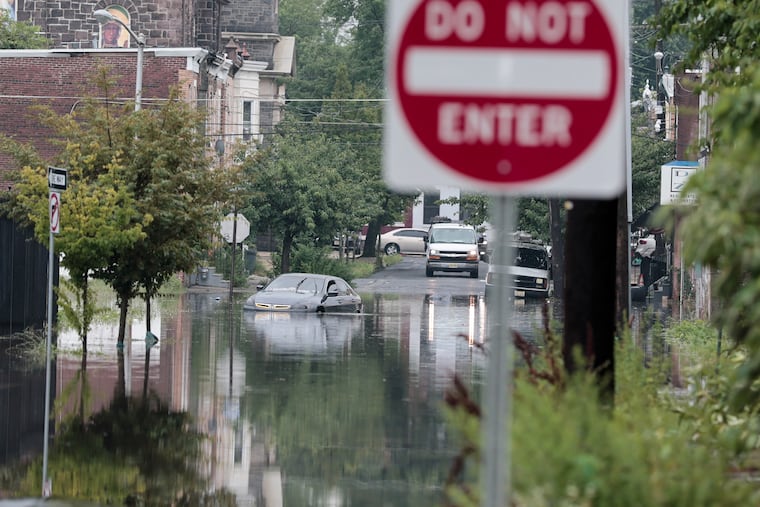
If you perceive that the Philadelphia region has had an extraordinary number of flood events this summer, you are not hallucinating.
The National Weather Service in Mount Holly has set a record for issuing flood warnings this year with 147 in its coverage area from Delaware to northern New Jersey, including 76 in the Philadelphia region, and monthly records in July and August. And an Inquirer analysis documented that among 2,200 U.S. counties, Philly and six of its neighboring counties rank in the top 25 for warnings issued this year, most of which have been followed by actual floods.
In addition, with four months to go, The Inquirer analysis found, the region already has had nearly triple the annual average for flood warnings, during the 18 years in which it has been using its current methodology.
All this without a whiff of a tropical-storm remnant, and the region still emerging from drought conditions.
The skies keep opening randomly, with no regard to what’s below, whether it be the most affluent communities, the likes of Upper Makefield Township, in Bucks County, to the cities of Camden and Chester, where 30% of the residents live in poverty.
George Wilson, emergency management chief in Bucks, which ranked in the top 10 for warnings, said “battle fatigue” among rescue workers is only a piece of the flooding ordeals, which empty into days of damage assessments and recovery assistance.
Just what the generous rains and the repeated “ring of fire” thunderstorms might have to do with the warming planet eludes certainty, said Sarah Johnson, the very busy warning coordination meteorologist in Mount Holly. Other factors, including improved radar and on-the-ground observations, likely have been factors in the increase of flooding reports, she said.
Johnson noted that given the lack of any tropical involvement — unlike 2020, and 2021, the year of Ida — this year’s numbers would be “pretty unusual.”
But if this has been a window into the future, said Dominick Mireles, Philadelphia’s deputy managing director of community safety, “We got a lot of experience this summer.”
What explains the onslaught
NASA estimates that rising temperatures across the planet have resulted in more evaporation and added about 7% additional water vapor to the air since the late 19th century.
Closer to home, it is possible that a pulse of above-normal sea-surface temperatures in June off the Mid-Atlantic coast, a key source of moisture for Philadelphia and the rest of the Northeast, may have added juice to the downpours, said Chad Merrill, senior meteorologist with AccuWeather.
The Northeast Regional Climate Center, in Ithaca, N.Y., reported that stations from Washington, D.C., to Massachusetts had rainfall far above normal from July 1 to Aug. 15.
As was the case this week, the I-95 corridor frequently has been on the edge of heat-producing high pressure, a hot spot for “ring of fire” thunderstorms to wring out the moisture.
The New York City weather service office had its second-busiest July for flood warnings and third-busiest August in data that covers the last 40 years, said Samantha Borisoff, researcher at the climate center.
Mount Holly’s numbers were triple those of New York’s.
What might explain why the Philadelphia region would be an atmospheric punching bag?
The best guess would by nature’s caprice, say meteorologists and emergency managers. Nothing personal: Flooding is a reality of life in a heavily urbanized area near so many bodies of water.
Very simply, “Flooding does happen in Philadelphia and throughout the Delaware Valley,” said Mireles. And much of it is the result of downpours that can target their ferocity to small geographic areas at any time.
A tragic example of atmospheric randomness was the 2023 deluge in Upper Makefield that killed seven people. Radar images showed most of the county didn’t experience a raindrop. The official total at Philadelphia International Airport that day was 0.00.
What are some of the region’s prime trouble spots
The Inquirer data show downpours rarely strike the same precise locations, which isn’t surprising given the small areal scale of most thunderstorms, and the region is short on flood-free zones.
Parts of all eight counties at some point have been deluge targets, according to weather service storm reports.
However, several general areas throughout the region have been flooded frequently, Upper Makefield being a prime example.
“We know River Road at certain points in Upper Makefield, they are going to flood,” said Wilson, as well as Station Avenue, at the lower end of the county in Bensalem Township. “That road has been a problem for all 52 years I have been alive.”
Germantown is among areas of Philly that historically has been flood prone, said Mireles. On the Camden flood honor roll would be Third Street, Cooper Street, and Admiral Wilson Boulevard
The Brandywine Creek has been a scenic gem in Chester County, but also a prolific source of flooding in places such as Downingtown and Kennett Square, noted Kelly Tinsman, the county’s deputy director for emergency management.
However, as would be the case throughout the region, “localized flash flooding … can quickly create response demands even in areas that not considered high-risk flood zones,” Tinsman said.
Are flood warnings reliable?
Emergency managers say they have had an excellent relationship with the weather service, which sends out email briefings when severe weather is threatening, sometimes days in advance.
However, they say they also realize that in the duel between science and atmospheric chaos, the smart money is on chaos.
“Weather predictions are just predictions,” said Joseph Hales, Camden County chief fire marshal and emergency management coordinator.
The weather service’s Johnson said that warnings preceded more than 90% of verified floods from 2017 through 2025. However, the false-alarm rate — warnings issued for floods that didn’t occur — was 38%.
Better to be warned than surprised, Hales said.
“We experience less issues and less calls for service with the storms that are predicted,” he said. People are less likely to be out and about taunting nature. The pop-up storms that catch people off guard are more problematic.
“For me, the moral of the story,” said Mireles, is that flooding happens, “warning, not warning; historical flood area or not.”