The nor’easter may foreshadow a busy and challenging season for forecasters and computers
The ultimate track of the nor'easter showed the limitations of computer models. Meanwhile, remnants of a tropical storm — from the Pacific — could impact the Philly region this weekend.
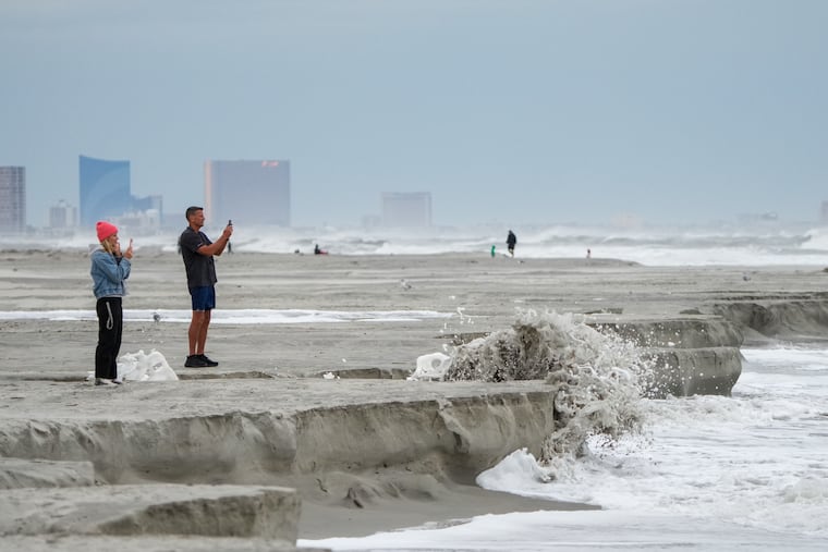
That erratically behaving nor’easter that really, finally, is done with the Philly region, not only was a spoiler for the last weekend of September, it may well have foreshadowed what’s to come — perhaps even in the very short term.
Along with being a possible prelude to the future of storm traffic, it also underscored the limitations of computer models that were late to latch on to the concept that the storm center improbably would make a left turn and wander onto the shores of New Jersey.
“There was a lot of evolution with this nor’easter,” said Allison Santorelli, meteorologist with the federal Weather Prediction Center, in College Park, Md., which, like Philadelphia, became a late addition to the roster of areas that would be affected by the storm.
And on the subject of improbability, in a season where not single a hurricane has formed in the Atlantic, the region may be affected by the remnants of a tropical storm this weekend — from the Pacific.
Santorelli said that some moisture from Hurricane Polo, due to make landfall in Baja California, could get picked up by a front and make it to the Mid-Atlantic during the weekend.
While October typically is one of the driest month of the year — and no rain fell in Philly during the month two years ago — another dousing would have to be considered “ill-timed,” said Ray Martin, a lead meteorologist in the National Weather Service office in Mount Holly.
In the last two months, 14 inches of rain officially have fallen on Philly, about double normal.
Forecast for the week
No rain is expected during what is forecast to be a splendid workweek with the sun (yes, coming soon to a horizon near you) due to return. Temperatures are expected to rise into the 70s and perhaps to 80 by Thursday and the low 80s Friday, without so much as a coastal flood advisory.
Incidentally, conditions will be similar in Atlanta, where the Phillies play the Braves in the wild-card round.
At least in the early going, Saturday also was looking decent, but rains might return Saturday night and continue Sunday as the aforementioned front stalls near the region and a storm develops.
Given the possible entrainment of Polo’s leftovers, “It could bring another slug of rain and gusty winds to areas impacted by this nor’easter,” said Carl Erickson, meteorologist with AccuWeather Inc.
For now, it doesn’t look “overly impactful,” said Santorelli. But she cautioned the threat was still several days away, and last weekend’s nor’easter looked very different in the middle of last week.
The nor’easter bedeviled computer models
The nor’easter was deteriorating Monday afternoon near Long Island and was poised to call it a career. And what a strange one it was.
Computer models had foreseen that a coastal storm would develop and its low pressure, or lighter air, would interact with the heavier air of potent high pressure to the north to generate beach-eroding winds and flooding tides.
In its Wednesday night discussion, the weather service said the storm “now overall looks to remain far enough offshore to keep heavy rains away from the region.”
Said Santorelli, “A lot of models had it as a classic nor’easter off the coast, with a lot of the Mid-Atlantic, including Philly … spared. Then all of sudden the models were like, ‘We’ll just stall off the East Coast for a day or two.’”
It wasn’t until Friday morning that the model consensus shifted to a track that would have the storm make a left turn and cross the Jersey Shore, inciting coastal flooding; gusty, erosional winds; and heavy rains throughout the Philadelphia region.
Totals of 3 to 5 inches were common, with more than 7 inches in Ocean County. Streets and bridges were closed in the beach towns.
Winds gusted past 60 mph at the Shore, and 50 mph across the region.
The computer modeling had caught on to storm potential early last week, and the weather service began sending out briefings to emergency managers Monday.
But, as usual, the details were elusive. The computers, said Erickson, constitute a “tool. Even if they get better and better with time there’s still a tool,”
That may be worth keeping in mind in the weeks ahead, particularly during the winter, said Santorelli.
Was the nor’easter a practice run?
The El Niño warming in the equatorial Pacific, which may reach record levels, almost certainly will have major impacts on the Philadelphia winter as the west-to-east upper level winds it generates persists for months.
That could lead to more nor’easters than typical, said Santorelli.
The quiet Atlantic tropical-storm season also may come into play, as it has resulted in quieter waters that have allowed sea-surface temperatures to warm, said AccuWeather’s Erickson. Warm waters would help provide sharp contrasts to cold air migrating off the coast, aiding winter-storm development.
Said Santorelli, “It’s still early to tell when they’re going to happen, where they’re going to happen, and who they’re going to impact, but certainly the potential is out there.”
And so is the potential for uncertainty, as the region just learned.